
Some Observations of Geotechnical Aspects of the February 28, 2001, Nisqually Earthquake in Olympia, South Seattle, and Tacoma, Washington
Soil Liquefaction and Ground Failure
Distribution and Characteristics of Liquefaction
The South of Downtown District in Seattle (SODO), and Olympia are located approximately 60 km and 35 km respectively from the approximate fault plane of the earthquake. Liquefaction of sands and silty sands was pervasive and manifested itself at ground level in the form of sand boils, ground cracking, pavement settlement, failure of overlying earth structures, etc.
South of Downtown Seattle
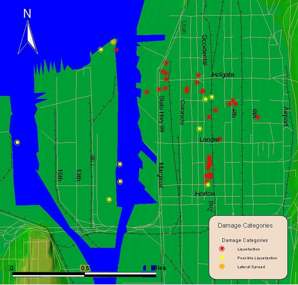
Map of the South of Downtown Seattle area, showing the location where soil
liquefaction, as evidenced by sand boils, was identified as well as possible liquefaction, which was interpreted from settlement of sidewalks and broken water mains.
A special section has been dedicated to the King County International Airport (Boeing Field) not shown on this map.
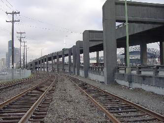
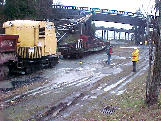
The northern boundary of observed liquefaction was found to begin in the vicinity of the southern end of the Alaskan Way Viaduct shown in the photo!!!!.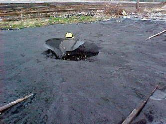
Large sinkhole of approximately 1.5 m diameter found south of the Alaskan Way viaduct. The diameter of the ejected sand is about 15 m. (N47.58577° W122.33971°; 03/02/2001)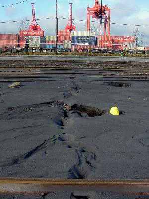
Sand ejected through a crack perpendicular to the rail tracks. The opening was found to run through the road (Marginal Way) and all the way into the port facilities seen in the background. (N47.58487° W122.33980°; 03/02/2001)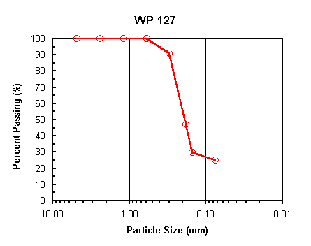
Particle size analysis test performed on the ejected soil collected in the vicinity of the sand boil shown to the left. The soil classifies as SM (Silty fine sand) according to the USCS. 25% in weight passes the #200 sieve. (N47.58637° W122.33969°)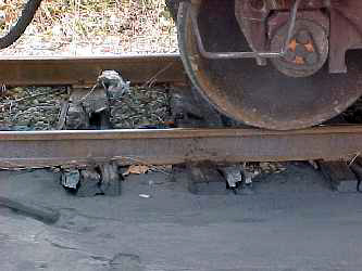
Cracking of wooden ties due to the load of the train in an area were ground loss caused loss of support. (N47.58487° W122.33980°; 03/02/2001)
Liquefied sand ejecta found along centerline of Utah Ave, near cross with Holgate St.The joint along the centerline seems to have opened approximately 2 cm to 3 cm. (N47.58541° W122.33512°; 03/03/2001)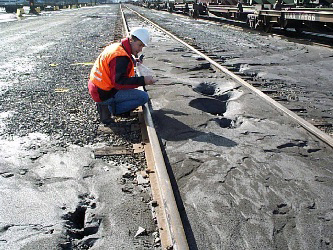
Sand boils found in Union Pacific train yard. (N47.58458° W122.33669°; 03/02/2001)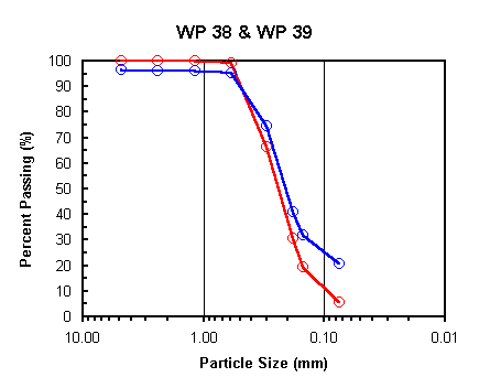
Particle size analysis tests performed on the ejected soil collected from the sand boil shown to the left. The soil grain size distribution varies. WP 38 (red) classifies as SP-SM (Poorly graded sand with silt), and WP 39 (blue) classifies as SM (Silty sand) according to the USCS. (N47.58482° W122.3367°, N47.58458° W122.33669°)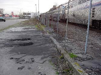
Liquefaction sand boil found east of the Amtrak car wash facilities. (N47.58324° W122.33034°; 03/03/2001)
Particle size analysis test performed on the ejected soil found at the site shown to the left. The soil classifies as SP (Poorly graded clean sand) according to the USCS. (N47.58324° W122.33034°)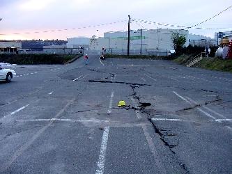
Cracks and warping of the pavement together with ejected sand found in a parking lot east of Boing Field. (N47.53390° W122.31405°; 03/03/2001)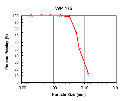
Particle size analysis test performed on the ejected soil shown to the left. The soil classifies as SP-SM (Poorly graded sand with silt) according to the USCS. (N47.53390° W122.31405°)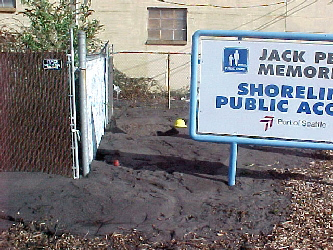
Extensive liquefaction as evidenced by sediment ejecta was observed in this area north of Terminal 30 at the Jack Perry Memorial Park. The 6 m-high building located directly adjacent to this area had no observable damage due to liquefaction. ( N47.58740° W122.33968°; 03/02/01)
Olympia and Tumwater
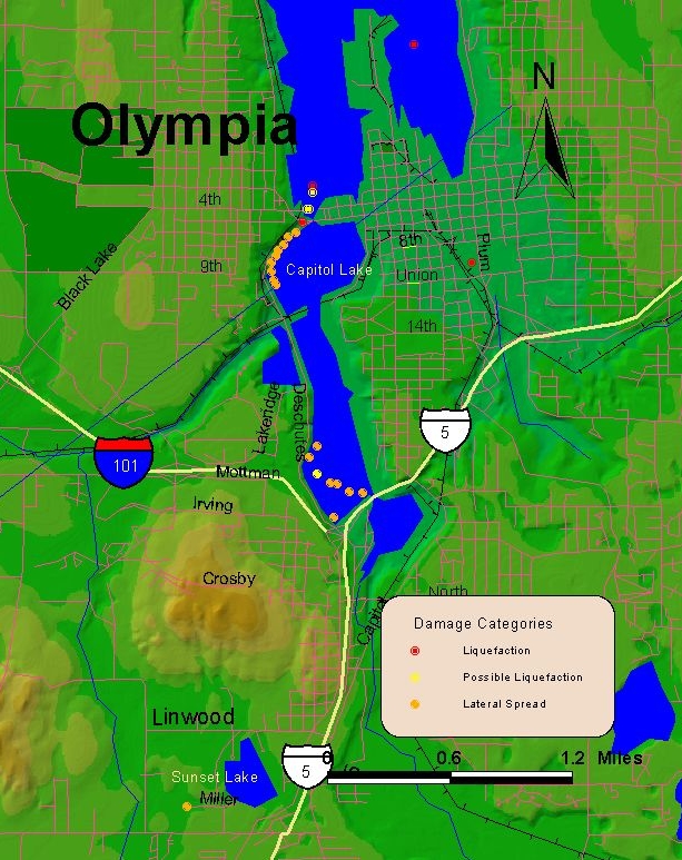
NOTE: Points mapped in blue areas (water) were identified in portions of land that have been filled in after the baseline map was drawn.
Numerous cases of liquefaction in the form of lateral spreads were observed in the Olympia-Tumwater area, these are reported in the lateral spread section. Level ground liquefaction was also observed in the Port of Olympia. Some others cases are documented as follows.
Large liquefaction sand boil on the rail tracks north of Deschutes Parkway. The bridge in the far background is the damaged 4th Ave. Bridge. (N47.04303° W122.91140°; 03/01/2001)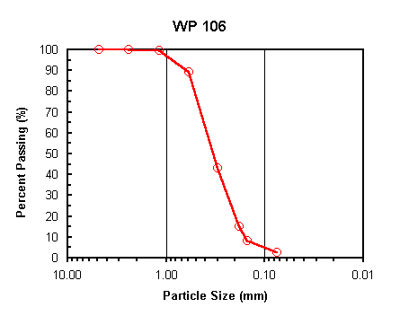
Particle size analysis test performed on the ejected soil found at the site shown to the left. The soil classifies as SP (Poorly graded clean fine sand) according to the USCS. (N47.04303° W122.91140°)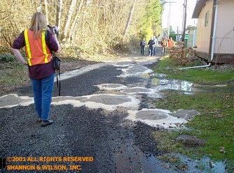
A line of sand boils along the eastern edge of Sunset Lake mobile home park, Tumwater. (N47.00165° W122.92351°, 02/28/2001)