
Some Observations of Geotechnical Aspects of the February 28, 2001, Nisqually Earthquake in Olympia, South Seattle, and Tacoma, Washington
Soil Liquefaction and Ground Failure
Lateral Spreads
Deschutes Parkway and Capitol Interpretive Center, Olympia
- - North Deschutes Parkway
- - East Capitol Lake
- - Marathon Park, Capitol Lake
- - Central West Deschutes Parkway
- - Railroad embankment west of State Capitol
- - Capitol Interpretive Center
Sunset Lake, Tumwater
Deschutes Parkway and Capitol Interpretive Center, Olympia
(click on marked areas for specific site coverage)
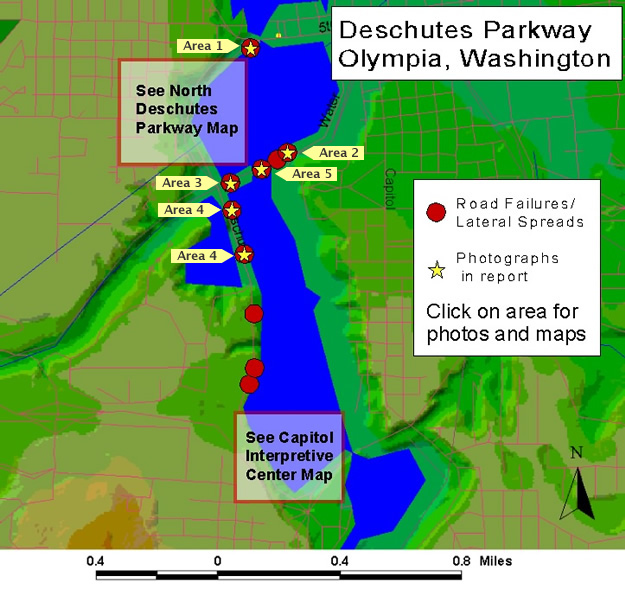
North Deschutes Parkway
North Deschutes Parkway Map
click on image to improve quality
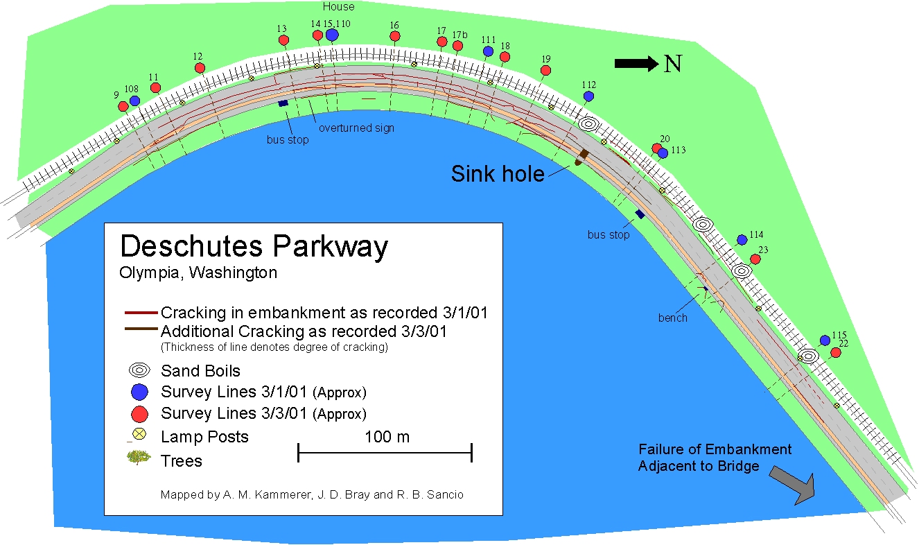
CROSS-SECTIONAL DISPLACEMENT MEASUREMENTS WERE TAKEN ON 03/01/2001 AND 03/03/2001 AT 9 LOCATIONS ACROSS THE EMBANKMENT STARTING AT THE WATER SIDE, CONTINUING ACROSS THE ROADWAY, AND FINISHING AT THE RAIL LINE. THESE PROFILE MEASUREMENTS WERE PERFORMED AT A NUMBER OF STATIONS ALONG THE ROAD AS INDICATED ON THE MAP BY THE RED DOTS.
Download these measurements (pdf file - 12 KB)
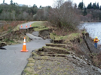
Ground failure along North Deschutes Parkway showing lateral spread toward Capital Lake, which is to the left of the photograph; view is to the south
(GPS N47.042° W122.913°; 1400 03/01/01)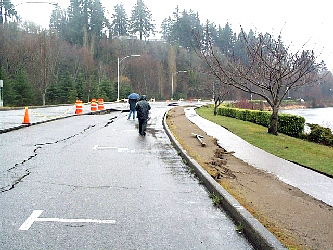
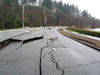
Pavement distress at North Deschutes Parkway; view is to the north.
( N47.040° W122.915°; 1330 03/01/01)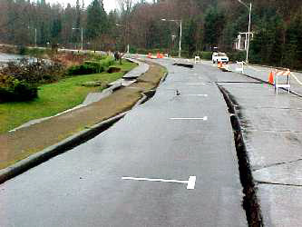
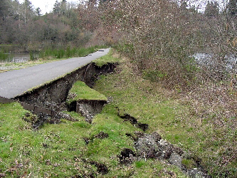
Ground failure along North Deschutes Parkway showing lateral spread toward Capitol Lake, which is to the right of the photograph; view is to the north.
(N47.040° W122.915°; 03/01/2001)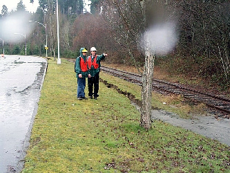
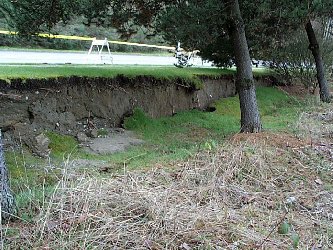
Back of lateral spread observed at the North Deschutes Parkway at the middle of the largest lateral spread feature. Sand ejecta can be seen in the lower right corner of the photograph. The crack shown in the middle of the photograph crosses the road near the second lamp post in the background of the picture; view is to the south and Capitol Lake is to the left.
(N47.041° W122.914°; 03/01/2001)- Area 1
Slope failure at the north end of the North Deschutes Parkway
(GPS N47.042° W122.912°; 1300 03/01/01) 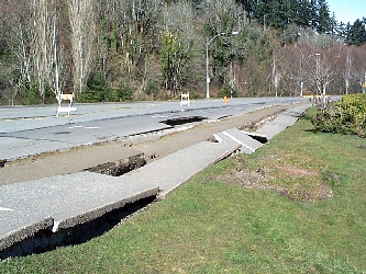
Distress to sidewalk and pavement at the North Deschutes Parkway; view is to the north.
(03/03/2001)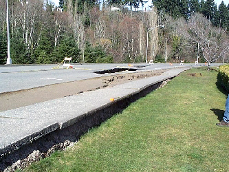
Distress to sidewalk and pavement at the North Deschutes Parkway; view is to the north.
(03/03/2001)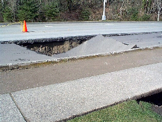
Sinkhole that developed in the days following the earthquake; significant damage was not observed at this location on 03/01/2001 immediately after the earthquake.
(03/03/2001)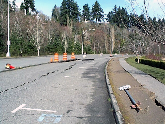
Pavement distress at the North Deschutes Parkway; view is to the north and Capitol Lake is to the right of the photograph; same view as photograph #2 above.
(03/03/01)
East Capitol Lake
Area 2
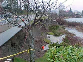
Lateral spread/slumping of newly constructed shoreline along the east side of Capitol Lake. Sand boils found in restricted access area beyond scope of this photo.
(N47.03810° W122.90695°; 03/03/2001)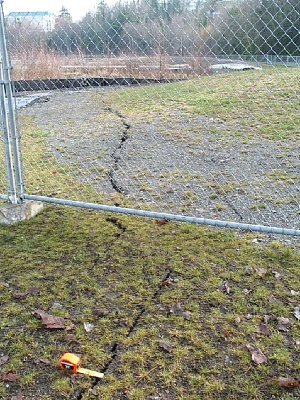
Cracking through recently placed fill.
(N47.03810° W122.90695°; 03/03/2001)
Marathon Park, Capitol Lake
Area 3
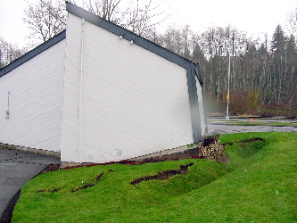
Ground distress around the structure that houses the bathrooms located south of Deschutes Parkway failure.
(N47.03677° W122.91150°; 03/01/2001)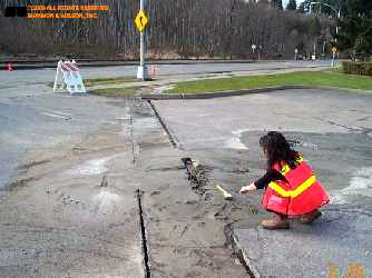
Sand boil at entrance of the Marathon Park parking lot.
Central West Deschutes Parkway
Area 4
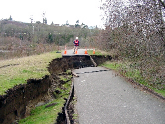
Road failure at Capitol Lake.
(N47.03578° W122.91188°; 02/28/2001)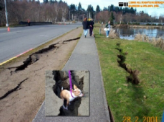
Large cracks along the direction of the road.
(N47.03578° W122.91188°; 02/28/2001)
Railroad embankment west of State Capitol
Area 5
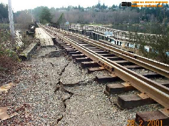
Lateral spreading of railroad embankment extending from Marathon Park (looking southwest).
(N47.03723° W122.90963°; 02/28/2001)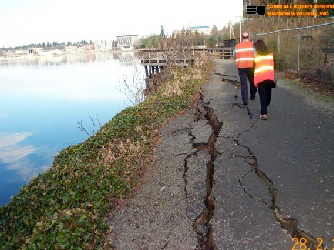
Lateral spreading of railroad embankment extending from Marathon Park (looking northeast).
(N47.03723° W122.90963°; 02/28/2001)
Capitol Interpretive Center
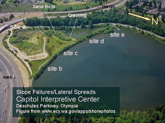
Site A
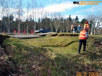
Head scarp of lateral spread showing remains of sand boil (after heavy rains). The total length of the scarp is approximately 200 feet with a maximum vertical drop of 3 feet.
(N47.04270° W122.91090°; 03/04/2001)
Head scarp (background) and tension crack lower in slope (foreground) in lateral spread.
(N47.04270° W122.91090°; 03/04/2001)
Site B
Lateral spread of embankment in Capitol Interpretive Center. The drop seen at the end is varies between 3 to 4 feet.
(N47.02386° W122.90520°; 03/04/2001)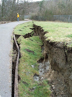
Sand boil in separation of soil in embankment of Capitol Interpretive Center. Note the rotation of blocks. Although not seen completely in the photo, the total length of the scarp is approximately 150 feet.
(N47.02386° W122.90520°; 03/04/2001)
Site C
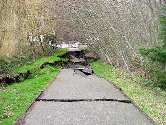
East to west view of lateral spread of embankment in Capitol Interpretive Center. The length of damage is approximately 75 feet.
(N47.02396° W122.90660°; 03/04/2001)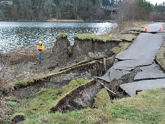
West to east view of embankment failure. Note translation and rotation of blocks.
(N47.02386° W122.90520°; 03/04/2001)
Site D
East to west view of an embankment failure (lateral spread) in Capitol Interpretive Center. This embankment failed towards the north. The failure shown in the photo to the right can be seen in the far end of the pathway.
(N47.02447° W122.90784°; 03/04/2001)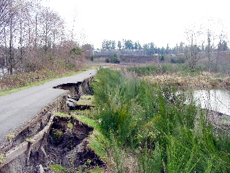
West to east view of an embankment failure (lateral spread) in Capitol Interpretive Center. This embankment failed towards the south.
(N47.02461° W122.90852°; 03/04/2001)
Site E
East to west failure of full width of embankment due to liquefaction. Note the rotation from vertical of the trees. This slide is located at a close distance from the restrooms of the Capitol Interpretive Center.
(N47.02525° W122.91000°; 03/04/2001)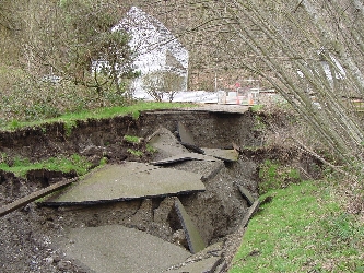
Close-up of head scarp. Note the rotation of blocks.
(N47.02525° W122.91000°; 03/04/2001)
Sunset Lake, Tumwater
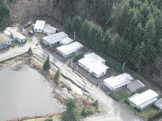
Aerial view of the flow slide that occured along a perimeter road of Sunset Lake. The street affected by the slide is roughly aligned north-south where north is towards the bottom right corner of the photo.
Liquefaction was also observed in the northeast corner of the Sunset Lake mobile home park. A gas pipeline in this area was ruptured.
(02/28/2001)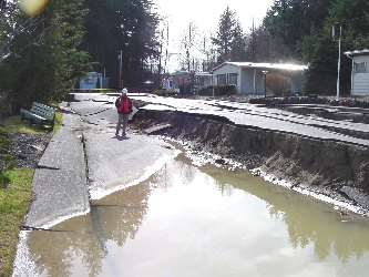
Area along the main drop where liquefaction sand boils were observed and a sample was collected. The vertical displacement along the scarp is approximately 3 feet.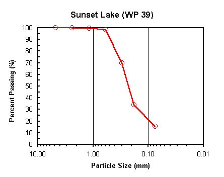
Particle size analysis test performed on the ejected soil collected along the main scarp of the slide. The soil classifies as SM (Silty fine sand) according to the USCS. 15% in weight passes the #200 sieve. (N47.00165° W122.92351°)