Humboldt

Home

Special Interest

bulletSite visit.  Six PEER researchers met in Eureka on Fri 16 Aug 2002.  We viewed the underside of the bridge from the deck of the historic MV Madaket, and later examined the abutments.  Caltrans' Richard Mullen and Jeff Bowser joined us.  Richard later provided as-built information.  A collection of digital photos is available for download.

For information about the Humboldt Bay Bridge testbed, please see the testbed managers' webpage.  This page contains supplementary and summary information. 

Page Contents

bulletSummary description
bulletList of available data files

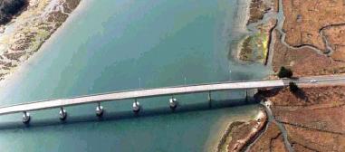
Summary Description

The subject bridge is the Middle Channel Bridge, one of three crossing Humboldt Bay on California State Route 255. It is located at 40.814N x 124.158W (location of CSMIP instrument 89735). The other two bridges are the Eureka Channel Bridge (40.809N x 124.154W, CSMIP 89736) and the Somoa Channel Bridge (40.822N x 124.169W, CSMIP 89686). The bridge (no 04-0229) is a 330m, nine-span composite bridge built in 1972. In 1992, it carried average daily traffic of 4,600 to 15,800.

Available Data Files

Notes:
Meeting presentations are located on the Meetings page. 
If you can't view a file by left-clicking, right-click, save the file to your hard drive ("Save Target As..."), and view that.

Hazard and sensors Design Photos, PEER reports, etc.
SOMERVILLE CALTRANS  
Somerville report on Humboldt ground motions Geotechnical studies (1) Draft bridge DVs
Ground motion README Geotechnical studies (2) Aug-16 site-visit photos
Somerville paper on near-fault ground motions Geotechnical studies (3) Report outline
2%/50 yr longit. motions Geotechnical studies (4) Table for comparing current practice with PEER approach
2%/50 yr longit. plots Seismic Design Criteria (SDC) Abstract  
2%/50 yr transv. motions SDC  
10%/50 yr longit. motions SDC Memo to Designers 20-1  
10%/50 yr longit. plots SDC Memo to Designers 20-1 Attachment 1  
10%/50 yr transv. motions    
50%/50 yr longit. motions    
50%/50 yr longit. plots    
50%/50 yr transv. motions    
Unscaled 2%/50 yr longit.    
Unscaled 10%/50yr longit    
Unscaled 50%/50yr longit    
SENSORS    
CSMIP 89509 Eureka    
CSMIP 89686 Samoa Ch    
CALTRANS HAZARD    
Caltrans seismic hazard map    
Caltrans seismic hazard map report