(CLICK ON IMAGE FOR BETTER QUALITY) | |||

 Drawings by: K. Ö. Çetin and M. T. Yilmaz | |||
| Location: Yalova Harbor, Yalova. | |||
| GPS Coordinates: 40.6597°N 29.2689°E | |||
(m) |
|||
click here for CPT log (.pdf) click here for CPT data file (.csv) |
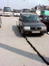 A view of the cracks at Yalova Harbor (Photo by J. Stewart) | ||
click here for CPT log (.pdf) click here for CPT data file (.csv) |
|||
click here for CPT log (.pdf) click here for CPT data file (.csv) |
19.12 | ||
click here for CPT log (.pdf) click here for CPT data file (.csv) |
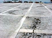 A view of the cracks at Yalova Harbor (Photo by J. Stewart) | ||
click here for boring log (.pdf) |
with SPT |
||
click here for boring log (.pdf) |
with SPT |
||
click here for boring log (.pdf) |
with SPT |
||
click here to download all CPT data files (.zip) click here to download all SPT logs in .pdf and .lpt format (.zip) .lpt can be viewed with the FREE Rockware LogView click here to download the setup file | |||
click here for shear wave velocity profile (.pdf) | |||