Data Structure of Ground Deformation Database
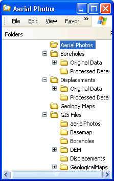
Figure 1 shows the file system and directory structure used to store information on the selected case history of ground deformation.
Figure 1. Data structure for case history of ground deformation
Information on case history is stored in 4 subdirectories:
Aerial Photos
Excel workbook AerialPhotos.xls in the directory Aerial Photos summarizes information on aerial photos.
Boreholes
& Displacements
Excel workbook DataSummary.xls summarizes information on
boreholes and displacements. It also contains earthquake information.
DataSummary.xls has seven worksheets:
Directory Original data contains scanned data used to
generate digital version of boreholes.
Directory Processed data contains Excel files and graphics of
boreholes.
Geological Maps
Excel workbook GeologyMaps.xls
in the directory Geological Maps summarizes information on
geological maps.
GIS files
Excel workbook GISFiles.xls in
the directory GIS Files summarizes information on GIS files. GIS files
are usable with Arcview and ArcInfo. GISFiles.xls has three
worksheets:
There are two types of GIS files:
Directory BaseMaps contains base maps that are GIS
enabled.
Directory DEM contains DEM files to generate
topography.