| Project Title/ID Number |
NGA: Site Condition Metadata
from Geology—1L05 |
| Start/End Dates |
4/1/03 – 6/30/04 |
| Project Leader |
C. Wills (CDC-CGS/O) |
| Team Members |
K. Clahan (CDC-CGS/O) |
F=faculty; GS=graduate student; US=undergraduate student; PD=post-doc; I=industrial
collaborator; O=other
Click on images to enlarge in a new window
1. Project Goals/Objectives:
Provide geology-based estimates of shear-wave velocity at all strong-motion
recording sites in the PEER-NGA database.
2.
Role of this project in supporting PEER’s mission
(vision):
The PEER Next Generation Attenuation Equation project and developers
of attenuation codes need to consider site conditions in seismic hazard
analysis. To accommodate this need, CGS is contributing to PEER’s
database of site conditions information for all strong motion stations
that have recorded earthquake ground motion.
3. Methodology Employed:
For this project CGS compares the locations of measurements of shear-wave
velocity with geologic maps to develop correlations between Vs and geologic
units; the summary statistics can then be applied to earthquake strong-motion
recording stations on those or similar geologic units.
4. Brief Description of past year’s accomplishments
(Year 6) & more detail on expected Year 7 accomplishments:
To expand the database of strong ground motion data and metadata, CGS has
added preliminary estimates of the average shear-wave velocity to 30 m each
of approximately 1200 sites based on existing GIS data. These estimates
have then been refined from the preliminary statewide site conditions map
based on existing data from measured shear-wave velocity profiles and newly
measured profiles, principally in areas where existing profile data is sparse
or lacking. Based on the available site conditions information, CGS has
estimated of the average shear wave velocity to 30 m for each site, including
the basis for the estimate and uncertainty.
5. Other Similar Work Being Conducted Within and Outside
PEER and How This Project Differs:
This work is based on generalizing the available measured shear-wave velocity
data by geologic unit, then finding the mean and range of shear-wave velocity
values for a particular unit. This approach allows for the calculation
of summary statistics of shear wave velocity properties that can be applied
to any location underlain by a particular unit.
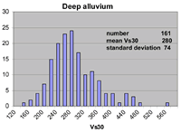
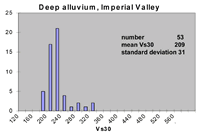
In this project we have examined weather units that have similar geologic
conditions have similar shear-wave velocity characteristics. As shown in
the charts above, alluvium in deep basins is not always similar in velocity.
The alluvium in the Imperial Valley is both lower in velocity and less
variable than in other basins, such as the Los Angeles basin. Assembling
these statistics enables us to provide estimates of velocity and uncertainty
for stations throughout California.
6. Plans for Year 8 if project is expected to be continued:
Future work will focus on providing velocity estimates for specific sites
where the generalized approach does not provide a sufficiently accurate
estimate, mainly sites where the geologic conditions change in the upper
30 m.
7. Describe any actual instances where you are aware your
results have been used in industry:
Velocity estimates based on this technique are the basis of the “Preliminary
site conditions map of California” which is used in estimating earthquake
ground shaking for emergency response through “ShakeMap”s and
is used in estimating future potential ground shaking used in setting earthquake
insurance rates in California though the California Earthquake Authority.
8. Expected Milestones & Deliverables:
-
Preliminary estimates of geologic units, Geomatrix classifications,
mean and Vs30 from geologic unit summaries completed March 2004.
-
Completion
of profiles for complex sites by June 2004.

