
Preliminary Observations from the Ferndale Area Earthquake of Jan 9, 2010
By PEER Director Stephen Mahin
The Ferndale Area Earthquake of Saturday, January 9, 2010 occurred at 4:27:38 PM (PST) and has a recorded magnitude of 6.5Mw.
For information on recorded ground motions see: http://www.strongmotioncenter.org/cgi-bin/ncesmd/iqr_dist_DM2.pl?iqrID=Ferndale_09Jan2010&SFlag=0&Flag=1 . In addition to information on the peak ground or structure accelerations, by clicking on various links you can see time histories of the recorded responses, information on the recorded site or building, and links to USGS, Shakemap and a nice CSMIP map of where the various instrument sites are located.
My plan was to go to as many SMIP instrument locations as possible, and to spread out from each looking for damage. I flew up, arriving at the Arcata Airport near McKinleyville at 8:30 AM and began looking, from North to South, until it was too dark to look any more. It was raining by late afternoon. In my travels, I kept an eye out for any repair or construction work that was going on, and stopped by several electrical substations, and other structures of interest. Generally, there was very little evidence of any earthquake related construction or repairs underway. I met up with Rune Storesund (of Storesund Consulting) in the mid afternoon. He is doing a preliminary geotechnical inspection for GEER and was raised in Eureka. He and his family were able to get me into a couple of buildings. Their assistance is greatly appreciated.
It must be recognized that what follows based on the observations of one person, and I may have missed some important damage.
Overall, most of the people I talked to in Eureka said that the shaking was quite violent, stronger than any previous earthquakes that they had experienced. They said that at their homes (I did not see them) a lot of material fell off of shelves and cracking of partitions/ceilings occurred, but no structural damage developed for those individuals I talked to. Even though most people I talked to said they had been through several previous earthquakes, of the half dozen offices and residential units I went through, no one had bolted bookshelves and similar cabinets to the walls. Nonetheless, only a few cabinets of bookshelves toppled (mainly in upper stories). This is of course a limited sample, so it should not be taken as a generalization. One person I talked to said the chimney on their house toppled, but I did not see it myself . This was the only incidence of chimney damage I saw or heard of.
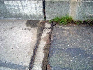
I tried to keep an eye out for signs of liquefaction or lateral spreading. Eureka has an enormous coastline and many marshes. Thus, there is a potential for a lot of liquefaction, but I did not see any significant evidence of it where I looked (waterfront in Old Town Eureka, Samoa Island, etc.). I am not and expert, and my search was not comprehensive. Rune was able to find some instances of lateral spreading, and he is continuing to look on Monday. There is evidence of small amounts of subsidence and lateral movement at Ray's Grocery and at the adjacent Bay Shore Mall.
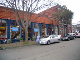
With regards to damage to structures, I saw virtually no major structural damage and very limited exterior cladding damage in areas even where ground motions are on order of 30%g (except for URMs). This held for older RC buildings, some with short columns, and for wood buildings of various types. There was moderate to serious content and interior partition damage in some buildings. In other buildings, there was little damage to contents (including falling damage).
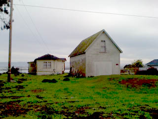
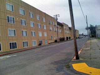
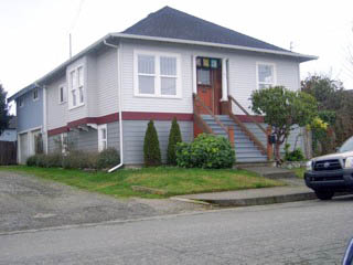
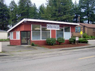
One reason I visited Eureka was to look at older wood building, especially ones supported on cripple walls. These are ones related to Plan Set A. There were many buildings of this type, ranging from old Victorians to perhaps 1970s-vintage houses. I was not able to find any seriously damaged buildings of this type. I am told that one that collapsed has been shown on TV . I could not find it. There are also more modern, multistory wood buildings. The two below show extremes of wood buildings. Neither appeared to damaged from looking at their exteriors.
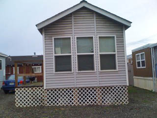
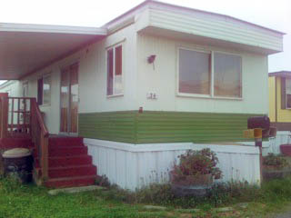
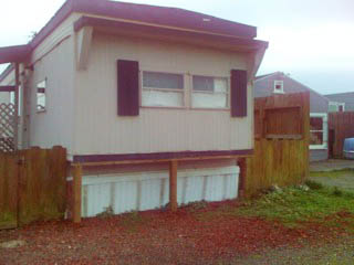
There are also lots of mobile homes. Many of these had no lateral bracing, and in most, it was difficult to see if there were lateral bracing, but my guess is that there was no lateral bracing due to the age of the mobile homes. I looked at four parks, two north, one in and one south of Eureka. I was not able to see any damage that looked like it was caused by this earthquake. There is evidence of lateral movement at the base of some mobile homes, but it looked old. The vertical supports under the end of the mobile home on the far right appeared to predate the earthquake.
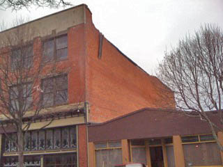
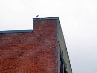
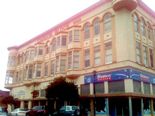
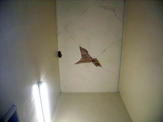
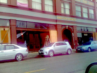
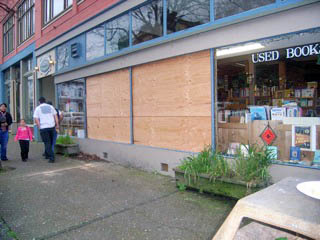
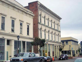
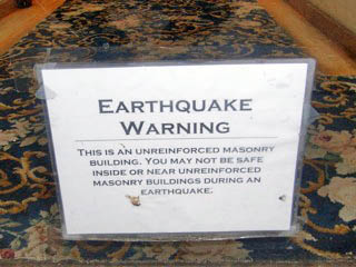
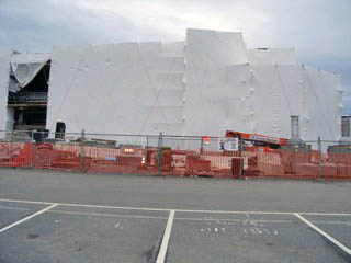
Eureka also has many URMs. These range from one story up to ones three or four stories tall. Most of these buildings had little apparent exterior damage. I found two that had broken windows at front at the ground floor level. I was able to go into two three story URMs and there was lots of cracking of interior lath and plaster walls and ceilings, even though the exteriors did not look too damaged. There are two large URMs in Old Town that are cordoned off. One lost a parapet that fell into an adjacent building. The other seems to be leaning slightly into the street. I was told by neighbors (not necessarily a reliable source of information) that both had been given a deferments in needing to meet the URM ordinance. I saw no classic examples of X cracking or similar structural damage in the masonry.
Some URMs appear to have varying amounts of retrofit, and did not suffer damage.
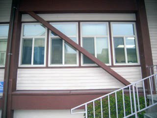
Some other wood/concrete buildings (State of California Office Building in Old Town District shown below) were retrofit with steel braces and did not seem to be damaged.
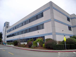
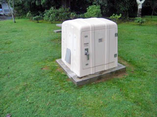
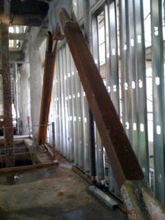
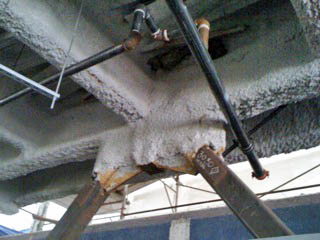
I spent a lot of time in St Joesph's Hospital. There will be a lot of useful information coming from these set of buildings. The hospital seems to have grown in stages, and they have ended up as one large organic building (vs. separate buildings). The first was done in the 1950s. I understand that there was additional addition in the 70s and two more in the 1990s. There is an old concrete frame, a concrete shear wall building, a tilt up, and a 1998 steel moment resisting frame. There appears to be 11 accelerometers in the 1978 RC shear wall building addition, and three more adjacent free field instruments (in one station shown below). The peak base acceleration was 29% g, the free field is 33%g, and the roof acceleration was 1.18g according to CSMIP. The hospital currently is in the process of adding an adjacent three story tall steel SCBF building with a large foot pring, and the hospital services will move into the new building in the Spring of 2011. There is no evidence of damage to the new building (see photo) and the braces do not appear to have yielded or buckled. The engineer for the new building (KPFF-LA) was arriving in the afternoon, and after examining the new building, he was going to look at the other parts of the building, especially the SMRF (shown in the middle photo below).
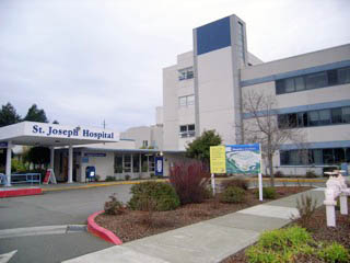
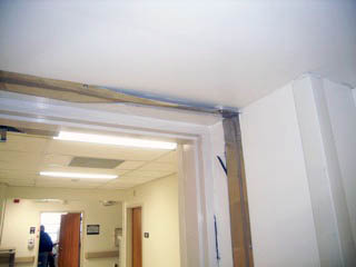
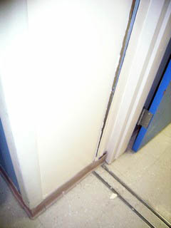
Most of the damage cosmetic to nonstructural elements, especially at the various expansion joints (only perhaps 2 or 4 inches in dimension), especially those adjacent to the steel SMRF. The elevators were not damaged, but the elevator company needed to restart them following the earthquake. The fire and other alarm system needed to be reset. There seemed to be excellent planning and implementation of a plan for response and recovery.
An interesting note is that the 1997 steel SMRF has significant damage to the nonstructural gypsum wallboard around stairs (see far right photo below). Damage to nonstructural elements in this part of the building is increasing during aftershocks.
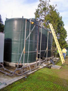
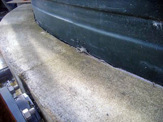
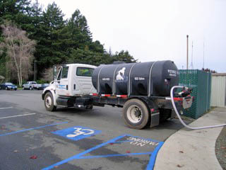
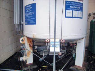
A water supply pipe started leaking in a mechanical room in one wing, but a nearby valve was shut off. Two 6000 gallon, plastic, auxiliary potable water tanks broke (they had a concrete restraining ring around their base and this seems to have sheared the plastic at the top of the ring). There was some damage to an evaporative cooler, but there was an active debate underway as to whether this preexisted the earthquake.
The new three story tall SCBF hospital replacement building is shown below.
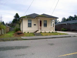
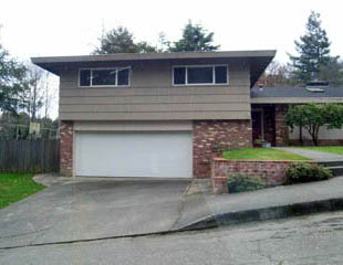
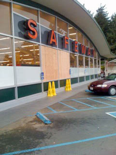
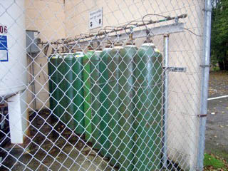
St Joseph's Hospital has a nearby general campus that is used for outpatient and administrative services. I had some ground supported equipment that did well, including a large liquid oxygen tank and several smaller bottle oxygen tanks. I also looked at the residential and commercial construction near the main hospital. The houses do not appear to have any damage, even ones on cripple walls. There is a shopping center a few blocks away that had a Safeway grocery story that had two broken windows. There was no indication of structural damage in the Safeway store. The last four wood buildings in the first set of photos in this email are all within a half mile of the St. Joseph's hospital.
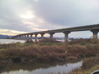
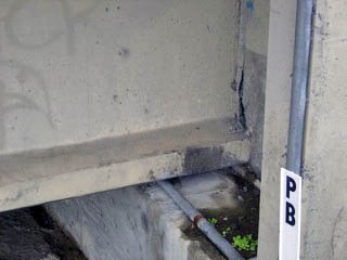
I also looked at several bridges, in particular the Middle Channel Bridge studied by PEER, and the Eureka channel bridge, and outer harbor bridge (see below). These have all be retrofit, and two of them have instrumentation by CSMIP. Peak accelerations are about 26%g-28%g. There was no evidence of any damage, other than very minor working at the end expansion joints and some cracking in the end diaphragms. used to restrain the precast concrete I-girders.
I ended the day trying to look at the Rio Dell bridge, but I could not find a way to get under the bridge legally. It is in operation, and seems ok (thought there is a slight bump on the north end, but that may have existed for some time). There is not evidence of any damage to other largely RC bridges that cross over highway 101. In the morning, Caltrans was clearing a large tree that had fallen on the freeway near Arcata.
Other sites of interest, or near instruments
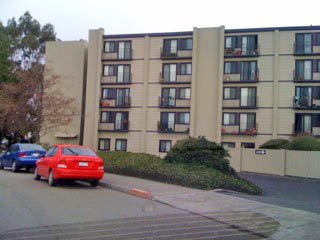
Five Story Masonry Apartment Building (on West Avenue between 6th and Myrtle ). I did not realize this was instrumented when I was in Eureka, but stopped by to look at it. There was no outward indication of structural damage where I looked, and there was not activity related to repair or cleaning up debris. The peak roof ground acceleration is about 26%g, and the roof acceleration is 70% g. There is a nearby (across the street in the Burre Shopping Center (near West and Myrtle).
Arcata Airport: A new RC building with a Glulam and timber roof. No damage. I asked maintenance workers, and they said there was no damage elsewhere at the airport.
Humbolt State University (Arcata): I did not see any damage. Students questioned said that they knew of none. Peak ground acceleration was 8.6%g.
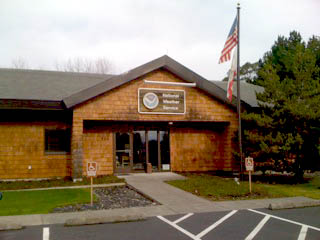
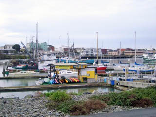
Marina: There is a large Marina on the island off of Eureka. There are several small wood buildings (NOA, Corps of Engineers, Coast Guard, Harbor Master, restaurant, etc.). Inspection of these buildings did not reveal any damage. Occupants said they had minor falling of contents. The emergency generator at the NOAA weather station worked fine, and their computers continued to work, and the radar was up within 15 minutes on emergency power. The docks did not appear to have any damage, nor did the embankment.
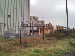
Substations and power generation facilities: I stopped by several substations while driving around, and saw no evidence of damage or recent repair activity. The photo below is of a small substation at an industrial plant on Samoa Island. There was no apparent damage. PGE is decommissioning a nuclear power plan in Eureka. There was a large and new substation and it seems to have no damage. There is work being done at the facility, but there was no indication that this was related to the earthquake.
Chevron Oil Docks: There is a pier and numerous large oil tanks. The tanks appear not to have suffered damage, and there was a ship off loading oil docked at the pier. No construction work was in evidence.
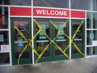
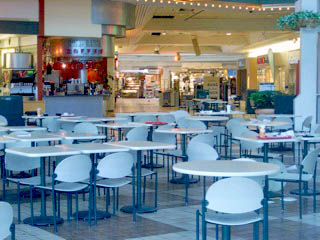
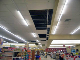
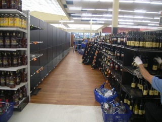
Bay Shore Mall: This is a very large shopping mall. 80% of the mall was closed. There was no evidence of structural damage from the outside, but looking through the windows, it was apparent that large portions of the ceilings, lighting fixtures and HVAC in the common areas has fallen. There were several (but by no means all) items of inventory had fallen on the floor in stores that were visible from the outside of the mall. One store (Kohl's) remained open and had little damage on the inside. The adjacent Ray's grocery, had large amounts of product still being put back on the shelves in late afternoon, large regions of the suspended ceiling had fallen (especially around the edges), and some damage to the floor (differential movement) were evident.
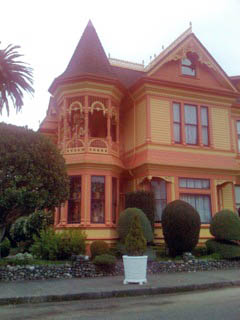
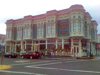
Ferndale: There seemed to be a lot of nice Victorian houses and commercial buildings that appeared to have soft stories or cripple walls. No damage was seen. CSMIP indicates that ground accelerations as great as 44%g were experienced in this area. CSMIP had not released information on the fire station and bed and breakfast before I left the Bay Area, so I did not look at them specifically, but there was virtually no damage to structures in town.
posted January 12, 2010